
Update: I tried this one again in July of 2012 and completed the 3 summits. You can read more about it here.
8000 6,638 Meter Challenge
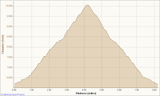
Jess and I set out Saturday, early, 4:30 AM, to climb three mountains, Mt. Baldy, Mt. San Gorgonio, and Mt. San Jacinto. It's called the 8,000 Meter Challenge -- 8,000 meters of elevation gain and loss, 13,123 feet of elevation gain. For me the challenge would end in the dark on Mt. San Jacinto at 6,638 meters, but it would start at the base of Mt. Baldy.
Mt. Baldy -- 10,066'
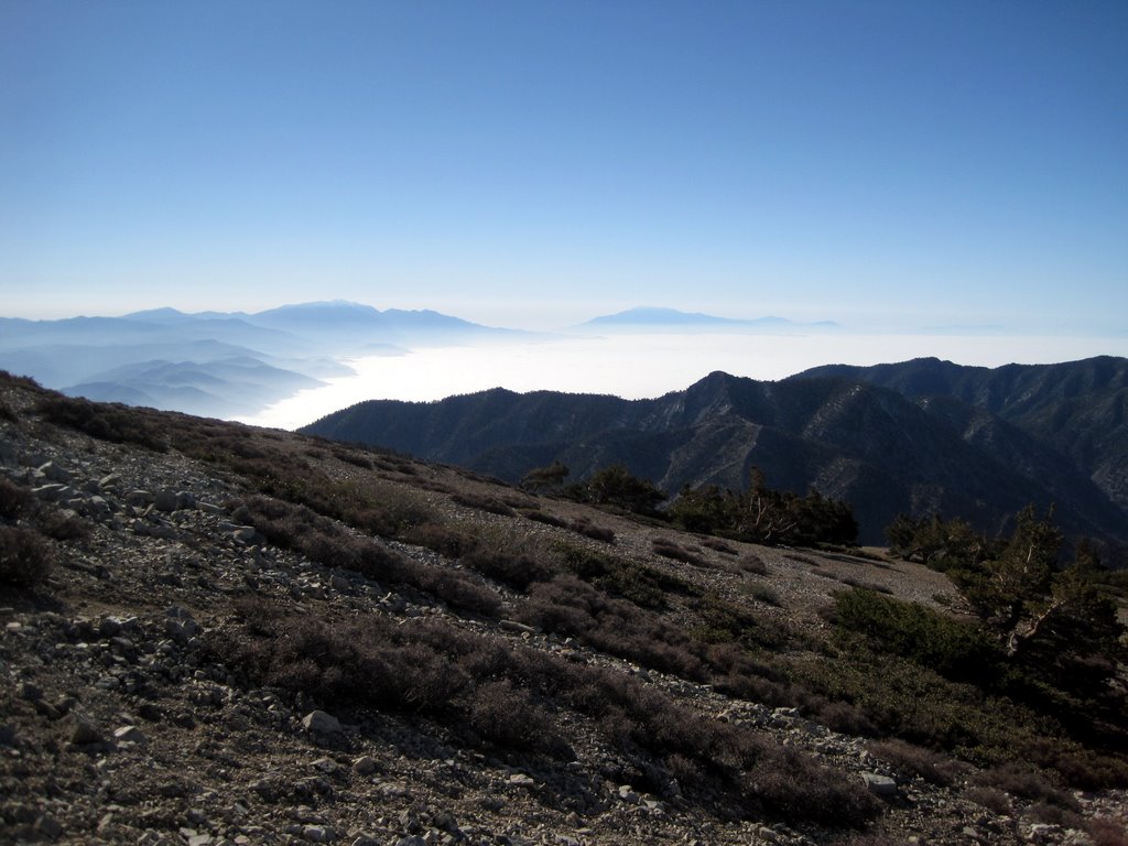
We started the hike up Mt. Baldy at 6:30 AM with Jess setting his usual speedhiking pace. The plan was to hike up the mountains and run down when the trail was runnable and not too steep. There were only a few hikers on the way up as we set a good pace and quickly climbed above the marine layer. We joined up with one other guy on the way up, went off trail and did some scrambling towards the top, but once we were there, we had the summit to ourselves. I was happy to see Tibetan prayer flags at the top, reminding me of Everest, and reminding me to take a moment and be grateful to be out there.
As we started the descent we quickly ran into crowds, passing a hundred or so hikers who were on their way up. We were able to run smoothly down most of the mountain and back to the truck for the drive to San Gorgonio.


Mt. San Gorgonio -- 11,499'
We lost some time on the drive to San Gorgonio, missing a turn and then backtracking. We also started the climb on the wrong trail, realizing after about 15 minutes of scurrying up rocks on hands and knees that this probably wasn't the right trail; it was supposed to be tough, but not this tough. We walked along the river until we hit the right trail and started the ascent.
The hike to the summit starts with some steep switchbacks, then a nice long stretch through a pine forest, along streams and past the misleadingly named "Halfway Camp." After the camp comes some long switchbacks were we encountered our first patches of snow, then a false summit, then a grueling ascent to the summit. I started feeling the effects of the elevation about a mile from the summit. I felt dizzy, lightheaded, head-achy, and dehydrated. I was carrying two liters of water, but realized that wasn't going to be enough about halfway up the ascent, so I started to conserve. It was a hot day and I wasn't taking in enough fluids, so I think that had a lot to do with the bonking sensation I was feeling towards the top. That last mile took me about 45 minutes, and it was the most difficult section of the day. Once at the top, some nice hikers gave us a few water purification tablets that we would be able to use at a stream about three miles down the mountain. I immediately felt better knowing that there would be more water soon, and if I ever do this again, water purification tablets are definitely something I will be carrying.
The descent was amazing. We hiked down the snowy and technical section at the top that lasted about a mile, then I ran. It was the perfect running trail, with just enough obstacles to keep it interesting. It felt great to open the stride up and run on pine needle covered trails in the shade of huge trees, through meadows and over streams. There were a couple times where my feet hit roots or rocks and I found myself flailing in mid-air, twisting to avoid a fall, and catching my balance at the last minute, but not wanting to stop. I could feel myself getting stronger as the altitude decreased.
We returned to the black truck that had been sitting out in the sun all day, soaking up the heat. I drank some hot water and ate some chocolate covered beef jerky (the chocolate chips from my trail mix had melted and covered all my food). It tasted good, and at the time I considered marketing the idea of chocolate covered beef jerky, but now I'm thinking it would only taste good after about 26 miles of hiking and running. We jumped in the truck and started the long and windy drive to Idyllwild and Mt. San Jacinto.
Elevation gain: 5,959'
Cumulative elevation gain: 9,985'
Ascent: 4:11
Descent: 2:25
Total mileage: 18.4
Cumulative mileage: 26.8


Mt. San Jacinto -- 10,834' (of which I did a very small fraction)
At this point I was done for the day. It was getting late, and I didn't have the motivation to climb the third peak. Jess still wanted to give it a try, so we decided to drive to the trailhead in Idyllwild and start up the trail at our own (differing) paces. I was planning on doing a couple of leisurely miles and turning back early, and Jess would probably do more, turn around and catch me on the way down, or continue to the summit and return to the truck where I would hopefully be sound asleep. It sounded like a great idea at the time, while the sun was still out.
I grabbed gloves, a jacket, a hat, and a headlamp and started hiking as the sun was setting. It was a beautiful sunset and I was happily snapping pictures, and feeling really good. I had hit my second or third wind, and I was even entertaining the idea of trying to catch Jess and summit the mountain. Then the sun went down, and I realized I was alone in the mountains...at night, and I started to hear all the mountain sounds that you don't hear when you are running at night with someone else. I also realized that I didn't grab the spare batteries for my headlamp, and I'm sure it was my imagination, but it seemed to be dimming. I decided to turn around and make my way back to the car. I'll admit it, I was a little scared, with thoughts of bears, mountain lions, women who like cats too much, and The Blair Witch Project running through my mind (sure I wimped out, but I'm still the toughest Brony I know).
I got back to the truck, took a baby wipe shower, changed my clothes, and just as I reclined my chair back to sleep, I see a headlamp come bobbing down the trail. I was glad to see Jess, who also started thinking about mountain lions and Blair Witches when the sun went down. We drove the two hours home, making a quick and glorious pit-stop at Arby's.
Elevation gain: 904'
Cumulative elevation gain: 10,889'
Ascent: :28
Descent: :28
Total mileage: 3
Cumulative mileage: 29.8


Jess and I set out Saturday, early, 4:30 AM, to climb three mountains, Mt. Baldy, Mt. San Gorgonio, and Mt. San Jacinto. It's called the 8,000 Meter Challenge -- 8,000 meters of elevation gain and loss, 13,123 feet of elevation gain. For me the challenge would end in the dark on Mt. San Jacinto at 6,638 meters, but it would start at the base of Mt. Baldy.
Mt. Baldy -- 10,066'
We started the hike up Mt. Baldy at 6:30 AM with Jess setting his usual speedhiking pace. The plan was to hike up the mountains and run down when the trail was runnable and not too steep. There were only a few hikers on the way up as we set a good pace and quickly climbed above the marine layer. We joined up with one other guy on the way up, went off trail and did some scrambling towards the top, but once we were there, we had the summit to ourselves. I was happy to see Tibetan prayer flags at the top, reminding me of Everest, and reminding me to take a moment and be grateful to be out there.
As we started the descent we quickly ran into crowds, passing a hundred or so hikers who were on their way up. We were able to run smoothly down most of the mountain and back to the truck for the drive to San Gorgonio.
Elevation gain: 4,026'
Ascent: 1:40
Descent: 1:05
Total Mileage: 8.4


 |
| We're number one |
Mt. San Gorgonio -- 11,499'
We lost some time on the drive to San Gorgonio, missing a turn and then backtracking. We also started the climb on the wrong trail, realizing after about 15 minutes of scurrying up rocks on hands and knees that this probably wasn't the right trail; it was supposed to be tough, but not this tough. We walked along the river until we hit the right trail and started the ascent.
The hike to the summit starts with some steep switchbacks, then a nice long stretch through a pine forest, along streams and past the misleadingly named "Halfway Camp." After the camp comes some long switchbacks were we encountered our first patches of snow, then a false summit, then a grueling ascent to the summit. I started feeling the effects of the elevation about a mile from the summit. I felt dizzy, lightheaded, head-achy, and dehydrated. I was carrying two liters of water, but realized that wasn't going to be enough about halfway up the ascent, so I started to conserve. It was a hot day and I wasn't taking in enough fluids, so I think that had a lot to do with the bonking sensation I was feeling towards the top. That last mile took me about 45 minutes, and it was the most difficult section of the day. Once at the top, some nice hikers gave us a few water purification tablets that we would be able to use at a stream about three miles down the mountain. I immediately felt better knowing that there would be more water soon, and if I ever do this again, water purification tablets are definitely something I will be carrying.
The descent was amazing. We hiked down the snowy and technical section at the top that lasted about a mile, then I ran. It was the perfect running trail, with just enough obstacles to keep it interesting. It felt great to open the stride up and run on pine needle covered trails in the shade of huge trees, through meadows and over streams. There were a couple times where my feet hit roots or rocks and I found myself flailing in mid-air, twisting to avoid a fall, and catching my balance at the last minute, but not wanting to stop. I could feel myself getting stronger as the altitude decreased.
We returned to the black truck that had been sitting out in the sun all day, soaking up the heat. I drank some hot water and ate some chocolate covered beef jerky (the chocolate chips from my trail mix had melted and covered all my food). It tasted good, and at the time I considered marketing the idea of chocolate covered beef jerky, but now I'm thinking it would only taste good after about 26 miles of hiking and running. We jumped in the truck and started the long and windy drive to Idyllwild and Mt. San Jacinto.
Elevation gain: 5,959'
Cumulative elevation gain: 9,985'
Ascent: 4:11
Descent: 2:25
Total mileage: 18.4
Cumulative mileage: 26.8


 |
| The perfect running trail |

 |
| Mt. San Jacinto, our next stop, behind us |

 |
| We're number two |

Mt. San Jacinto -- 10,834' (of which I did a very small fraction)
At this point I was done for the day. It was getting late, and I didn't have the motivation to climb the third peak. Jess still wanted to give it a try, so we decided to drive to the trailhead in Idyllwild and start up the trail at our own (differing) paces. I was planning on doing a couple of leisurely miles and turning back early, and Jess would probably do more, turn around and catch me on the way down, or continue to the summit and return to the truck where I would hopefully be sound asleep. It sounded like a great idea at the time, while the sun was still out.
I grabbed gloves, a jacket, a hat, and a headlamp and started hiking as the sun was setting. It was a beautiful sunset and I was happily snapping pictures, and feeling really good. I had hit my second or third wind, and I was even entertaining the idea of trying to catch Jess and summit the mountain. Then the sun went down, and I realized I was alone in the mountains...at night, and I started to hear all the mountain sounds that you don't hear when you are running at night with someone else. I also realized that I didn't grab the spare batteries for my headlamp, and I'm sure it was my imagination, but it seemed to be dimming. I decided to turn around and make my way back to the car. I'll admit it, I was a little scared, with thoughts of bears, mountain lions, women who like cats too much, and The Blair Witch Project running through my mind (sure I wimped out, but I'm still the toughest Brony I know).
I got back to the truck, took a baby wipe shower, changed my clothes, and just as I reclined my chair back to sleep, I see a headlamp come bobbing down the trail. I was glad to see Jess, who also started thinking about mountain lions and Blair Witches when the sun went down. We drove the two hours home, making a quick and glorious pit-stop at Arby's.
Elevation gain: 904'
Cumulative elevation gain: 10,889'
Ascent: :28
Descent: :28
Total mileage: 3
Cumulative mileage: 29.8


 |
| This reminds me of the time I spent on Mars |
I'm doing this next month. Wish me luck!
ReplyDeleteThanks for the info. ;)
Jo Lynn -- Have a great time. They are all beautiful trails.
ReplyDeletenice project... will you try it again next year ?
ReplyDeleteI think we're going to try it again. Maybe change a couple of things...stay closer to Baldy and start earlier.
ReplyDeleteI work at an REI in northern California and we want to get a team together for the 2012 event! I can't seem to find an official website for it though, anybody know where to find it?
ReplyDeleteThank you!
emily
The event is closed to industry and shop employees only so there is no official site. JanSport does an amazing job organizing the event, providing a free dinner and breakfast the morning after. I've completed the event 4 times and I'm rented to do it again, which reflects how "fun" it can be. It is one of the most physically challenging things you'll do in your life. If you have questions call Ryan at the REI in HB CA.
ReplyDelete